


Having updated its Automated Enforcement System (AES) since October 2023, One of the Open System of Automated Awareness Safety System (AWAS) Speed Camera has positioned itself as the premium frontrunner of automated enforcement of traffic rules in Malaysia. Road safety concerns, improving compliance of speed limits and in the reduction of traffic collisions have merited the installation of the AWAS, which utilizes the sophisticated Automated Number Plate Recognition (ANPR) technology as well as point-to-point speed detection. From 2025, the AWAS Speed Camera system integrates ANPR with the monitoring of around major urban areas as well as highways and crammed regions including accident prone stretches, toll, and rush areas. The system not only marks the records of speed but is also able in the future to detect other traffic discrepancies including, at red lights and overloaded vehicles with High Speed Weigh in Motion (HS-WIM).
In this document, explain how Malaysia AWAS speed camera works, its kilometer captures, and integration with other types of vehicles like lorries. Automated and meticulous integration is missing so this works as a filler. The rest of the document covers from reliable and update posts the location of AWAS speed cameras for the year 2025 so that drivers can be aware and prepare for safety.
How AWAS Speed Camera Works: Explained In Detail
Unlike its predecessor, AES, AWAS has been crafted to be more sophisticated, rectifying some of the loopholes that traditional enforcement structures have, while using AI and sophisticated sensors to monitor with precision and protection from tampering. It is best understood with a systematic approach:
AWAS Technology Overview
- Sensors & Detection: AWAS uses in-situ sensors (inductive loops or piezos) with radar or lidar to measure vehicle speed by timing movement over a set distance. For example, if a vehicle exceeds the highway speed limit (e.g., 110 km/h), enforcement is triggered. Advanced systems like Ekin Spotter cameras offer 360° monitoring and can detect speeds up to 320 km/h.
- Automated Number Plate Recognition (ANPR): High-speed cameras identify vehicles in real-time, with data securely stored to prevent tampering. The system works in low-light or dark conditions.
- Point-to-Point Monitoring: Unlike spot-check cameras, AWAS calculates average speed over a highway stretch (e.g., KL-Karak or North-South Expressway). It records number plates and times at entry/exit points. For example, a 30-minute journey completed in 20 minutes flags a violation.
- Violation Processing: When speeding (with a 10 km/h tolerance) or red-light violations (0.01-second tolerance) are detected, AI captures images and generates a “State Shift Dipol” with details like time, date, location, and offense type. Data is sent to the JPJ’s MySikap database for owner identification. After human verification, summons are mailed, and points are added to the driver’s license via the Kejara system. Too many points may lead to license suspension.
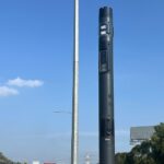
- Additional Features: AWAS also detects red-light violations, illegal U-turns, and plans to monitor HS-WIM in the future. Black pole cameras and clear signage encourage compliance.
This system has proven effective in reducing accidents, with strategic placements in high-risk areas. For the latest updates, drivers can check the official JPJ website or use apps like Waze for real-time alerts, though these may not always reflect new installations.
Question: If I’m Behind a Lorry, How Does It Detect My Car?
One of the worries of drivers is whether AWAS can recognize smaller vehicles, like cars, when they are sitting behind larger vehicles like lorries or trucks. This is especially true of busy highways, which are notorious for visibility impairment. Let’s put technology away for a second and examine the things for what they are:
Spot-Speed Mode (Like AES)
- Sensors: Inductive loops or piezos in the road detect a car’s metallic mass, even behind a lorry, and calculate speed from loop activation times.
- Radar/Lidar: Systems like Ekin Spotter use 360° or rear-aiming radar/lidar to avoid obstructions. ANPR identifies plates, even if partially blocked.
- Multi-Lane Roads: Your car’s speed is detected independently, and both you and the lorry are flagged separately if speeding.
Point-to-Point Mode
- Average Speed: Entry/exit cameras capture plates and timestamps from overhead or side angles. Being behind a lorry doesn’t affect detection, as it’s based on plate readability.
- Reliability: AI ensures accurate plate capture across multiple frames. If a plate is blocked, no data is recorded, preventing false positives.
Overall, AWAS is strong to common covering as lorries with its sensor diversity and ANPR focus, but will other measures as safe distance and speed regardless, as the system encourages the safe driving behavior above the evasion efforts.”
Question: Can AWAS Calculate Speed if I Skip the Middle Camera?
Yes, AWAS can still calculate your speed if you skip the middle camera, as long as the 1st and 3rd cameras capture your license plate. Here’s how:
How Point-to-Point Systems Work
- AWAS cameras (e.g., KL-Karak or North-South Expressway) record your license plate and timestamp at entry and exit points. Average speed is calculated by dividing the distance by the time taken. For example, a 50 km stretch at 110 km/h should take 27+ minutes. Completing it in 20 minutes (150 km/h average) flags a violation.
- Middle cameras enhance monitoring but aren’t needed for speed calculation.
What Happens if You Skip a Camera?
- Speed Calculation: If the 1st and 3rd cameras capture your plate, AWAS calculates average speed between those points, even if you miss the middle camera (e.g., due to lane changes).
- Exiting/Re-entering: Speed is calculated using 1st and 3rd camera timestamps if both capture your plate. No violation is issued if the entry/exit pair is incomplete.
Edge Cases
- Camera Issues: If the middle camera fails (e.g., weather, obstructions), speed is still calculated using the 1st and 3rd cameras.
- Evasion Attempts: Exiting/re-entering may not work, as toll booths or re-entry points often have cameras. JPJ may check toll data for patterns (not automatic).
- Fairness: No plate capture at the 1st or 3rd camera means no violation. You can appeal to JPJ with evidence like GPS or toll receipts.
Tips to Avoid Fines
- Drive within the speed limit consistently.
- Speeding up and slowing down doesn’t help if the average speed is too high.
- Look for AWAS signs (1-5 km before cameras) and check JPJ or Waze for camera locations.
Practical Advice To reduce the chances of getting a fine, keep a constant speed within the speed limit for the whole distance that you are monitored. Remember that the average speed is what the point-to-point systems take into consideration; therefore speeding over the limit after one camera, and then going below the limit before the next one, will not be beneficial if the overall timing is too low. Look out for AWAS signs (usually 1-5 km before the cameras) and track new installations via JPJ or Waze apps.
AWAS Speed Camera Locations List and Maps for Year 2025
The following list for 2025 contains the latest information provided by the JPJ regarding the geo-location of every AWAS Camera arranged by their respective regional roads and highways. Each entry contains the Camera’s Kilometer (KM) position, along with the speed limit, geo-direction, and state. These speed and traffic light cameras (Had Laju and Lampu Isyarat) are included. New installations occur every day so always check the JPJ website for added cameras.
North-South Expressway (Lebuhraya Utara-Selatan / PLUS Highway)
| KM Marker | Location | Speed Limit | Direction | State |
|---|---|---|---|---|
| KM 1 | Johor Bahru | 110 km/h | South | Johor |
| KM 1 | Johor Bahru | 110 km/h | North | Johor |
| KM 146.8 | Pagoh | 110 km/h | South | Johor |
| KM 151.4 | Pagoh | 110 km/h | North | Melaka |
| KM 185 | Bemban | 110 km/h | South | Melaka |
| KM 184.2 | Jasin | 110 km/h | North | Melaka |
| KM 214.4 | Alor Gajah | 110 km/h | South | Melaka |
| KM 214.4 | Alor Gajah | 110 km/h | North | Melaka |
| KM 301.6 | Kajang | 90 km/h | North | Selangor |
| KM 382.8 | Behrang | 110 km/h | South | Perak |
| KM 204.6 | Taiping | 110 km/h | North | Perak |
| KM 299.9 | Kampar | 110 km/h | North | Perak |
| KM 375.9 | Slim River | 110 km/h | North | Perak |
| KM 166 | Seberang Perai Selatan | 110 km/h | South | Pulau Pinang |
| KM 97.2 | Kuala Muda | 110 km/h | North | Kedah |
| KM 174 | Bandar Baharu | 110 km/h | North | Kedah |
Kajang-Seremban Highway (Lebuhraya Kajang-Seremban / LEKAS)
| KM Marker | Location | Speed Limit | Direction | State |
|---|---|---|---|---|
| KM 21 | – | 110 km/h | South | Negeri Sembilan |
| KM 21 | – | 110 km/h | North | Negeri Sembilan |
ELITE Highway (Lebuhraya ELITE)
| KM Marker | Location | Speed Limit | Direction | State |
|---|---|---|---|---|
| KM 17 | – | 110 km/h | South | Selangor |
| KM 28.4 | – | 110 km/h | North | Selangor |
Guthrie Highway (Lebuhraya Guthrie)
| KM Marker | Location | Speed Limit | Direction | State |
|---|---|---|---|---|
| KM 18 | – | 110 km/h | South | Selangor |
| KM 18 | – | 110 km/h | North | Selangor |
South Klang Valley Expressway (Jalan Kajang/Puchong / SKVE)
| KM Marker | Location | Speed Limit | Direction | State |
|---|---|---|---|---|
| KM 6.6 | – | 80 km/h | Puchong to Kajang | Selangor |
Jalan Lebuh Sentosa
| KM Marker | Location | Speed Limit | Direction | State |
|---|---|---|---|---|
| KM 1.6 | – | 70 km/h | Kajang to PICC | WP Putrajaya |
Other Roads
| KM Marker | Location/Road | Speed Limit | Direction | State |
|---|---|---|---|---|
| KM 85.5 | Jalan Ipoh – Kuala Lumpur, Sungkai | 90 km/h | South | Perak |
| KM 17 | Gua Musang – Kuala Krai | 90 km/h | Towards Kota Bharu | Kelantan |
| KM 256.1 | East Coast Expressway 2 (LPT2) | 110 km/h | Towards Kuala Lumpur | Terengganu |
| KM 288.6 | East Coast Expressway 2 (LPT2) | 110 km/h | Towards Kuala Terengganu | Terengganu |
Traffic Light Camera Locations
WP Kuala Lumpur
- Jalan Klang Lama (Towards Puchong)
- Jalan Ipoh (Towards Sentul)
Perak
- Jalan Pasir Putih, Ipoh (Towards Pasir Panji)
- KM 26, Jalan Ipoh – Kuala Kangsar, Sg Siput (Towards Kuala Kangsar)
- KM 4, Jalan Setiawan-Lumut/Manjung (Towards Lumut)
- KM 4, Jalan Setiawan-Lumut/Manjung (Towards Setiawan)
- KM 116, Ipoh – Kuala Lumpur / Batang Padang – Slim River (Towards Kuala Lumpur)
- KM 116, Ipoh – Kuala Lumpur / Batang Padang – Slim River (Towards Ipoh)
- KM 11, Jalan Setiawan Ipoh (Towards Setiawan)
- KM 14, Jalan Ipoh – Pusing, Ipoh (Towards Setiawan)
- KM 38, Jalan Ipoh (Partial list; additional locations may exist)
This list covers 45+ known AWAS installations, with 29 focused on speed traps and 16 on traffic lights. For point-to-point pilots, monitor stretches like KL-Karak and NSE segments. Stay updated via JPJ’s official channels, as expansions continue in 2025.
By understanding AWAS and respecting speed limits, you contribute to safer roads for everyone. Drive responsibly!
